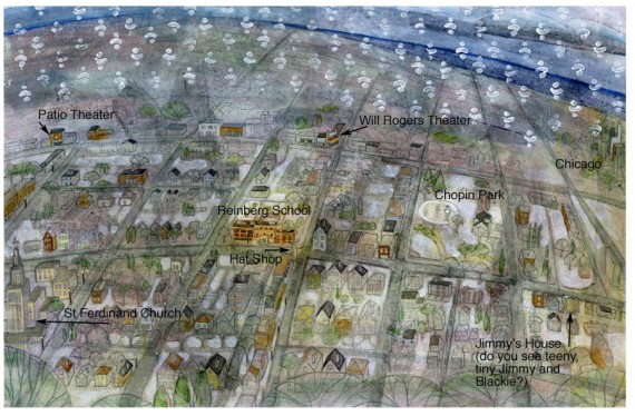
Final fly leaf art with added labels
By the Illustrator, Lisa Mertins
Remember me? I’ve been in the art cave for the past six weeks painting. All socializing, blogging and showering came to a screeching halt so I could complete the paintings and I’m starting with the (next to) last image I finished to demonstrate the final steps of my painting process.
Once I’ve added gesso, I can draw on top of all the under painting. It’s a little difficult to see details at this stage so I will sometimes use more gesso to bring out details if they are hard for me to see.
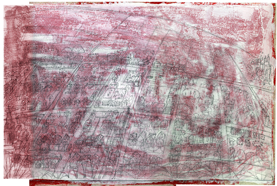
Final drawing that I will paint over
OI! This map was the most labor intensive of all the pieces. I intended to draw it first but kept avoiding it, knowing what a bear it would be. I’m showing this final illustration first because of how fun it ended up being.
It wouldn’t have been as interesting for me if it weren’t for the internet and Google Earth particularly. I was really able to geek out on details through pictures I found online of Jimmy’s North West Chicago neighborhood. I really enjoyed looking at
John Chuckman’s Chicago site
for reference (how I wish I’d found it before I worked on the map!!)
Getting a perspective that would show Reinberg school, St Ferdinand church (not mentioned in the book but a gorgeous mid-century piece of architecture that was fun to draw) and the Will Rogers theater that Jim wanted included was made simple thanks to GE.
That said, the map is skewed and inaccurate due to my need to include things like downtown Chicago (it’s further south than my map shows). For this blog post, I’ve labeled points of interest. Jim and I talked about adding link information in the final book. That way, readers can see where I’ve placed story references, including a Jimmy and Blackie
easter egg
if it works out.
Regarding the Will Rogers Theater, Jim wanted it included even though it’s been demolished. Thankfully, the
Patio Theater
is a fully restored gem that I drew in it’s somewhat correct place.
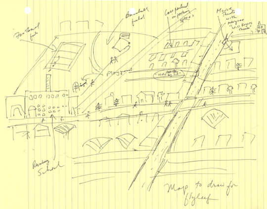
Jim's drawing of the book's fly leafs for reference
I used Jim’s map as a starting point — it has a different perspective than mine. I spent many years drawing maps at the Register newspaper and the rule was to keep them oriented with north at the top. If you were to look up Reinberg school on Google maps you’d see there are buildings where I’ve drawn the playground and that I’ve put the front of the building facing south when it faces west in reality. Jim pointed out I should show the big doors so there will be a visual reference to the story on the map.
Another difference is I put Jimmy’s mom’s hat shop closer to the school, an artist prerogative since I had to draw so small and needed to fit the word hat on a sign.
I wanted to keep an essence of A Christmas Adventure’ so I added stamped “snow” to the map. Drawing and painting this piece, while difficult, really added to a 50’s era for me anyway.
If you enjoyed this article, please consider sharing it!


