GCI Presidential Fellow Receives $1.01M NASA Grant Dr. Joshua Fisher receives grant to help water management in the US
June 20, 2022
Congratulations to Grand Challenges Initiative Presidential Fellow Dr. Joshua Fisher for receiving the NASA Earth Science Applications: Water Resources grant of $1.01M. He will use NASA data to help water management in the United States. Dr. Fisher is the Presidential Fellow of Ecosystem Science, focusing on terrestrial ecosystems, water, carbon, and nutrient cycling.

In this project, Fisher and colleagues will work closely with the New Mexico Office of the State Engineer (NMOSE) to utilize prototype hydrological remote sensing tools to use remotely sensed data to measure water levels. This data will identify the best water management for agriculture, forest and ecosystem monitoring, and drought response and mobilization within communities.
“This project allows us to tackle intensifying water issues in the driest parts of the US using NASA data,” shared Fisher. With the awarding of the NASA budget and resources, Fisher will be able to continue his research on creating a better allocation of water and identifying issues within dry areas of the United States. “I am excited to lead cutting-edge science that directly helps people and our Nation,” said Fisher.
Read the official project technical summary below.
This is a Category 3 proposal (Proven Application and Full Transition to Operational Partner) moving an established set of prototype hydrological remote sensing tools in use (Applications Readiness Level, ARL 7) and demand by the state operational water agency for New Mexico, the Office of the State Engineer (NMOSE), into full operations and transition to the partner (ARL 9). New Mexico is the only state that is in the top-10 driest and poorest states in the US [Saha et al., 2010; Smith, 2014].
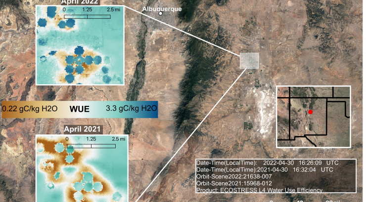
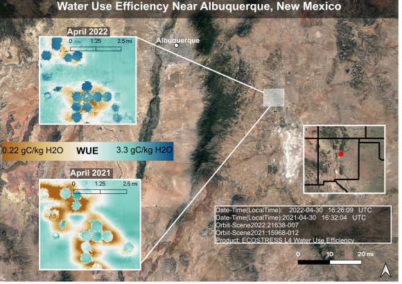
The remote sensing water management system enables the State to use remotely sensed data for decision-making across water rights management and agriculture, forest and ecosystem monitoring, and drought response and mobilization. NMOSE accesses a unique 7.3 TB, 30+ year record of Landsat-based evapotranspiration (ET) and evaporative stress data developed and produced specifically for the State, including continuous near real time updates, which are visualized in a dashboard co-designed by our technical team and NMOSE to match NMOSE and downstream partner requirements. The data and tools are invaluable to the State, as summarized by Craig D. Cathey of NMOSE, “The data will be extremely useful for me…I will use it for accurately determining non-use/abandonment and potential payback over years where I had no information or data of any kind.” According to NASA’s Western Water Applications Office (WWAO), the data and tools may save the State millions of dollars per year and facilitate a more accurate and precise management of precious water resources.
The technical data system currently runs on NASA servers accessible only by the NASA technical team, and data are pushed to NMOSE individual NMOSE users by NASA. For NMOSE’s decision-making application of water rights, for example, new water rights transfer applications are received by NMOSE, who then send the property boundaries to the NASA team to run through the system, and the results are sent back to NMOSE. Here, we propose to transfer the technical system entirely to NMOSE. Moreover, we propose to conduct numerous in person and online trainings for the many NMOSE users, as well as complete thorough documentation and user guides. Finally, we will conduct a quantitative and qualitative impact assessment of the system and develop extensions for potentially scaling the system to other states.
These objectives are summarized here:
- Technical transition of data system from NASA to NMOSE;
- Training, documentation, refinement, and technical support;
- Impact assessment, technical support, and extensions development.
This project is considered as a top priority for the NASA Earth Science Applications: Water Resources program, as one that achieves the final ARL 9 after years of technical and partner development, and for a geographic area and institution that not only needs such a system, but also has broad-reaching impacts. It is challenging to achieve ARL 9—a primary goal of NASA Earth Science Applications. Most projects do not attempt it and many projects never achieve it, leaving NASA with a lot of tools without users. Few projects exist in the ‘sweet spot’ of being on the cusp and within sight of ARL 9; this project is one of them. We have already addressed questions of partner relationship development, user requirements, tool functionality, and impact at this stage of ARL 7/Phase III—the hardest work of these elements has been completed. But, the last few ARL’s take some work, time, and care, and this proposal carefully considers these final steps.