Experiencing the Mappiest Place on Earth Faculty and students attend ESRI User Conference, the world’s largest gathering of GIS professionals
July 7, 2016
An urban planner, a geographer, and a sociologist walk into a bar. No, it’s not the beginning of a bad joke—it’s just another day at the world’s largest gathering of GIS (Geographic Information Systems) professionals, the ESRI User Conference held annually in San Diego, CA.

A sign at the conference hints at how GIS can aid in urban planning, public works, community development.
This conference may be the “mappiest place on Earth,” bringing together nearly 17,000 professionals from a diverse range of fields, across public and private sectors, to be inspired by their peers’ GIS work, and to learn about the latest geospatial methods, research, and cutting-edge technology.
But wait, “what’s GIS?” you might ask. If you’ve ever used Google Maps, you’ve used GIS (okay, it’s a bit more complex than that). Want to know whether crime hot spots are associated with street lighting? Ever wondered whether the distance from parks impacts people’s likelihood of exercising? GIS can help answer these questions.
I presented at the Education Conference, where GIS educators share valuable pedagogical lessons and best practices to help them maximize student learning in this rapidly evolving field. In my session on Service Learning, I described the benefits and challenges in using service learning projects in an introductory GIS course (ENV 310 here at Chapman). Other great presentations included a non-profit organization using GIS and student interns to aid in their conservation efforts, and a New Zealand organization using GIS to help clients have a central site to find information about service availability near them.

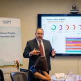
Dr. Georgiana Bostean presenting at the ESRI Education conference
For students, there are many unique attractions, including hands-on GIS learning activities, map consulting services with expert cartographers, and enthralling keynote addresses by provoking thought leaders. This year, the New York Times bestselling author, Andrea Wulf, spoke passionately about Alexander von Humboldt’s major (but today, nearly forgotten) influence on our conception of nature and the importance of conservation.
This year, two Chapman students had the opportunity to experience this huge and unique event, or more appropriately, “experience.” K.C. Hoppel and Derek Itagaki are environmental science & policy majors who were students in the Intro to GIS course I taught in Spring, 2016. Here’s what K.C. had to say about the ESRI conference:
“Walking into the Esri User Conference, I was astounded by the amount of people, but also the amount of knowledge and passion that was present. Walking away, I had a better understanding of how critical GIS work is in visualizing the evolving environmental, economic, and social problems we face today. I would recommend the conference to any one interested in learning about the interconnectedness of things and the groundbreaking technology being implemented to show this relationship.” – K.C. Hoppel
Sound intriguing? Students receive a free day pass to the event! So, next year make sure to check out the 2017 ESRI User Conference website and join 17,000 of your closest GIS professionals to find out for yourself what all the fuss is about.
And if you find yourself wanting to know more, check out our ENV 310 course!

Even with 17,000 attendees, we still ran into our neighbors, the GIS team from the City of Orange Public Works Department.
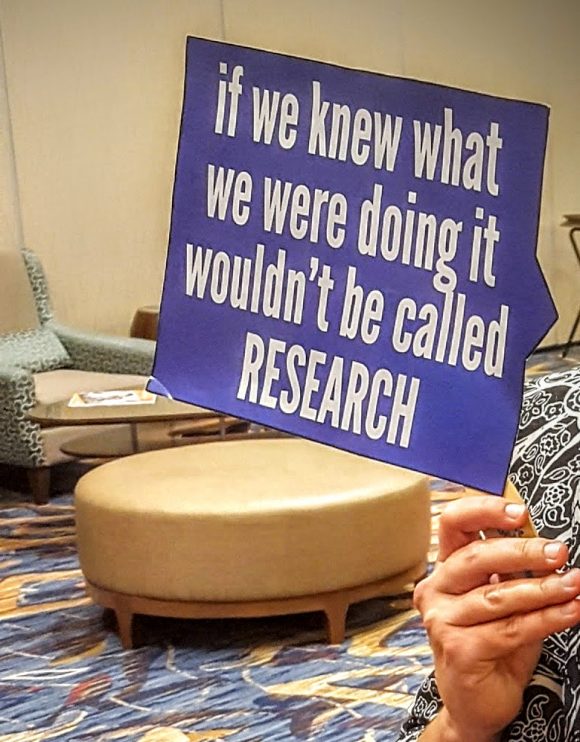
Science humor abounds at the ESRI UC